 vesseltracker.com
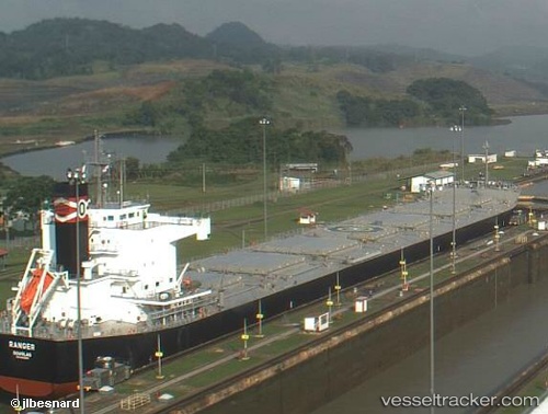
 RANGER
Current Status
Where is the vessel?
RANGER is currently in Near Altenwerder, based on AIS data received about 1h ago.
Latest AIS update:
Current position: 53.51869° N, 9.94359° E (Near Altenwerder)
Average speed (last 7 days): Loading…
Average speed (last 30 days): Loading…
Vessel profile: RANGER is a Bulk Carrier with dimensions 229m x 32m.
This page combines live AIS, route history, probable destination signals, nearby traffic, and port activity for practical vessel monitoring.
The current position of vessel RANGER is 53.51869 lat / 9.94359 lng. Updated: 2026-04-20 05:59:38 UTCNearest reference points:
- Near Bahrenfeld
- Near Hamburg-Mitte
- Near Allermöhe
Currently sailing under the flag of Liberia ![]()
RANGER built in 2012 year
Deadweight:
82172 tDetails:
Live Vessel RANGER Analytics (details, animations, etc.)
Recent AIS points (UTC):
2026-04-20 02:21:55 UTC · 53.69982, 9.49314 · SOG 11.8 kn · COG 155°2026-04-20 03:44:45 UTC · 53.55266, 9.80968 · SOG 10.5 kn · COG 106°
2026-04-20 04:36:13 UTC · 53.52265, 9.93883 · SOG 4.3 kn · COG 175°
2026-04-20 05:59:38 UTC · 53.51869, 9.94359 · SOG 0 kn · COG 283°