 vesseltracker.com
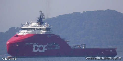
Skandi Angra
Current StatusWhere is the vessel?
Skandi Angra is currently in Near PORTO DO ACU, based on AIS data received less than 1h ago.
Latest AIS update:
Current position: 21.85403° S, 41.00795° W (Near PORTO DO ACU)
Average speed (last 7 days): Loading…
Average speed (last 30 days): Loading…
Vessel profile: Skandi Angra is a Offshore Tug Supply Ship with dimensions 22m x 93m.
This page combines live AIS, route history, probable destination signals, nearby traffic, and port activity for practical vessel monitoring.
The current position of vessel Skandi Angra is -21.85403 lat / -41.00795 lng. Updated: 2026-04-02 11:36:38 UTCNearest reference points:
- Near PORTO DO ACU
- 24 nm SE of Carapebus
- Near Fluminense FPSO
Details:
Live Vessel Skandi Angra Analytics (details, animations, etc.)
Recent AIS points (UTC):
2026-04-02 05:38:39 UTC · -22.16333, -40.46500 · SOG 8 kn · COG -1°2026-04-02 07:46:28 UTC · -21.94432, -40.75194 · SOG 9.5 kn · COG 309°
2026-04-02 10:18:06 UTC · -21.83310, -40.96808 · SOG 1.4 kn · COG 298°
2026-04-02 11:36:38 UTC · -21.85403, -41.00795 · SOG 0 kn · COG 330°