 vesseltracker.com
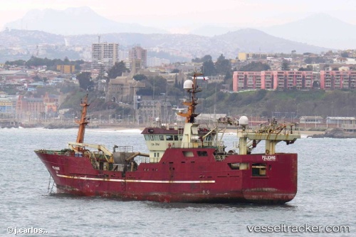
Pam Pelicano
Current StatusWhere is the vessel?
Pam Pelicano is currently in Near Coronel, based on AIS data received less than 1h ago.
Latest AIS update:
Current position: 37.02671° S, 73.15623° W (Near Coronel)
Average speed (last 7 days): Loading…
Average speed (last 30 days): Loading…
Vessel profile: Pam Pelicano is a Fish Carrier with dimensions 12m x 53m.
This page combines live AIS, route history, probable destination signals, nearby traffic, and port activity for practical vessel monitoring.
The current position of vessel Pam Pelicano is -37.02671 lat / -73.15623 lng. Updated: 2026-04-04 19:56:41 UTCNearest reference points:
- Near Arauco
Details:
Live Vessel Pam Pelicano Analytics (details, animations, etc.)
Recent AIS points (UTC):
2026-04-04 14:01:32 UTC · -37.02665, -73.15620 · SOG 0.1 kn · COG 48°2026-04-04 16:20:32 UTC · -37.02667, -73.15625 · SOG 0 kn · COG 49°
2026-04-04 18:16:32 UTC · -37.02667, -73.15619 · SOG 0 kn · COG 47°
2026-04-04 19:56:41 UTC · -37.02671, -73.15623 · SOG 0 kn · COG 48°