 vesseltracker.com
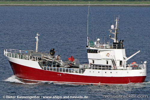
Brudanes
Current StatusWhere is the vessel?
Brudanes is currently in 51 nm W of Torres del Paine, based on AIS data received about 1h ago.
Latest AIS update:
Current position: 50.82833° S, 74.36500° W (51 nm W of Torres del Paine)
Average speed (last 7 days): Loading…
Average speed (last 30 days): Loading…
Vessel profile: Brudanes is a Fish Carrier with dimensions 8m x 49m.
This page combines live AIS, route history, probable destination signals, nearby traffic, and port activity for practical vessel monitoring.
The current position of vessel Brudanes is -50.82833 lat / -74.36500 lng. Updated: 2026-04-06 01:50:36 UTCDetails:
Live Vessel Brudanes Analytics (details, animations, etc.)
Recent AIS points (UTC):
2026-04-05 19:43:52 UTC · -50.04858, -74.57337 · SOG 9.5 kn · COG 228°2026-04-05 22:20:03 UTC · -50.43411, -74.83102 · SOG 9.8 kn · COG 177°
2026-04-06 00:04:03 UTC · -50.66533, -74.65756 · SOG 8.6 kn · COG 132°
2026-04-06 01:50:36 UTC · -50.82833, -74.36500 · SOG 8 kn · COG -1°