 vesseltracker.com
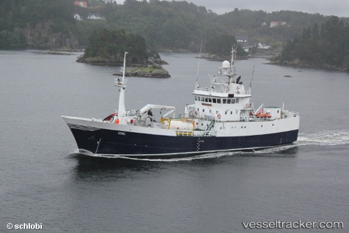
 Seivaag
Current Status
Where is the vessel?
Seivaag is currently in Near Vevang, based on AIS data received less than 1h ago.
Latest AIS update:
Current position: 63.05200° N, 7.44057° E (Near Vevang)
Average speed (last 7 days): Loading…
Average speed (last 30 days): Loading…
Vessel profile: Seivaag is a Fish Carrier with dimensions 56m x 10m.
This page combines live AIS, route history, probable destination signals, nearby traffic, and port activity for practical vessel monitoring.
The current position of vessel Seivaag is 63.05200 lat / 7.44057 lng. Updated: 2026-04-02 15:27:56 UTCNearest reference points:
- Near ELNESVAGEN
- Near Kristiansund
- Near Aukra
Currently sailing under the flag of Norway ![]()
Seivaag built in 1978 year
Deadweight:
900 tDetails:
Live Vessel Seivaag Analytics (details, animations, etc.)
Recent AIS points (UTC):
2026-04-02 09:58:06 UTC · 63.05202, 7.44055 · SOG 0 kn · COG -1°2026-04-02 12:00:12 UTC · 63.05203, 7.44049 · SOG 0 kn · COG -1°
2026-04-02 13:57:58 UTC · 63.05203, 7.44057 · SOG 0 kn · COG -1°
2026-04-02 15:27:56 UTC · 63.05200, 7.44057 · SOG 0 kn · COG -1°