 vesseltracker.com
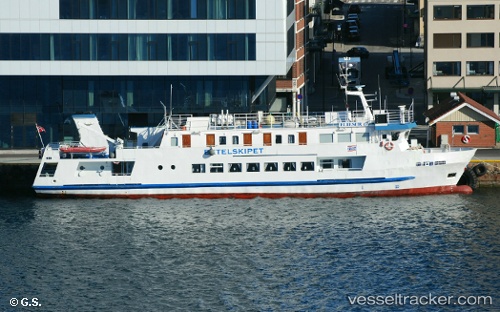
 Elieser 6
Current Status
Where is the vessel?
Elieser 6 is currently in Near Kristiansand, based on AIS data received about 1h ago.
Latest AIS update:
Current position: 58.14927° N, 8.03725° E (Near Kristiansand)
Average speed (last 7 days): Loading…
Average speed (last 30 days): Loading…
Vessel profile: Elieser 6 is a Passenger Ship with dimensions 39m x 8m.
This page combines live AIS, route history, probable destination signals, nearby traffic, and port activity for practical vessel monitoring.
The current position of vessel Elieser 6 is 58.14927 lat / 8.03725 lng. Updated: 2026-04-02 05:52:20 UTCNearest reference points:
- Near Kristiansand
- 27 nm N of HANSTHOLM
- 28 nm NW of Lokken
Currently sailing under the flag of Norway ![]()
Elieser 6 built in 1980 year
Deadweight:
50 tDetails:
Live Vessel Elieser 6 Analytics (details, animations, etc.)
Recent AIS points (UTC):
2026-04-02 00:09:50 UTC · 58.14929, 8.03720 · SOG 0 kn · COG 304°2026-04-02 02:10:59 UTC · 58.14926, 8.03721 · SOG 0 kn · COG 303°
2026-04-02 03:45:50 UTC · 58.14929, 8.03723 · SOG 0 kn · COG 303°
2026-04-02 05:52:20 UTC · 58.14927, 8.03725 · SOG 0 kn · COG 303°