 vesseltracker.com
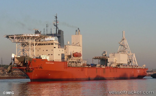
Mafuta
Current StatusWhere is the vessel?
Mafuta is currently in 81 nm W of Aussenkehr, based on AIS data received less than 1h ago.
Latest AIS update:
Current position: 28.70851° S, 15.90619° E (81 nm W of Aussenkehr)
Average speed (last 7 days): Loading…
Average speed (last 30 days): Loading…
Vessel profile: Mafuta is a Service Ship with dimensions 28m x 160m.
This page combines live AIS, route history, probable destination signals, nearby traffic, and port activity for practical vessel monitoring.
The current position of vessel Mafuta is -28.70851 lat / 15.90619 lng. Updated: 2026-04-19 09:35:47 UTCNearest reference points:
- 161 nm W of Koiingnaas
- Near Luderitz Bay
- 154 nm W of Koiingnaas
Details:
Live Vessel Mafuta Analytics (details, animations, etc.)
Recent AIS points (UTC):
2026-04-19 04:04:07 UTC · -28.72343, 15.90416 · SOG 0.5 kn · COG 188°2026-04-19 05:36:07 UTC · -28.71815, 15.90555 · SOG 0.8 kn · COG 180°
2026-04-19 07:34:48 UTC · -28.72270, 15.89686 · SOG 0 kn · COG 226°
2026-04-19 09:35:47 UTC · -28.70851, 15.90619 · SOG 2 kn · COG 218°