 vesseltracker.com
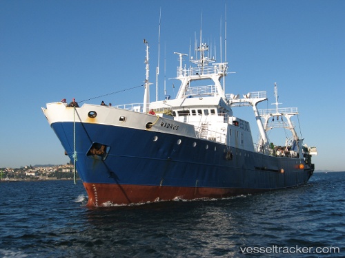
Madrus
Current StatusWhere is the vessel?
Madrus is currently in Near Montevideo, based on AIS data received about 1h ago.
Latest AIS update:
Current position: 34.89909° S, 56.20779° W (Near Montevideo)
Average speed (last 7 days): Loading…
Average speed (last 30 days): Loading…
Vessel profile: Madrus is a Fishing Vessel with dimensions 12m x 74m.
This page combines live AIS, route history, probable destination signals, nearby traffic, and port activity for practical vessel monitoring.
The current position of vessel Madrus is -34.89909 lat / -56.20779 lng. Updated: 2026-04-16 01:51:01 UTCNearest reference points:
- 16 nm N of Cabo San Antonio
- 12 nm S of Piriápolis
- Near JUAN LACAZE
Details:
Live Vessel Madrus Analytics (details, animations, etc.)
Recent AIS points (UTC):
2026-04-15 19:26:53 UTC · -34.89918, -56.20782 · SOG 0 kn · COG -1°2026-04-15 22:20:43 UTC · -34.89914, -56.20782 · SOG 0 kn · COG 89°
2026-04-15 23:44:53 UTC · -34.89918, -56.20791 · SOG 0.1 kn · COG 70°
2026-04-16 01:51:01 UTC · -34.89909, -56.20779 · SOG 0 kn · COG 69°