 vesseltracker.com
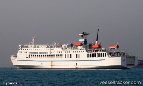
 Port Link Iii
Current Status
Where is the vessel?
Port Link Iii is currently in Near MERAK, based on AIS data received less than 1h ago.
Latest AIS update:
Current position: 5.93564° S, 105.99883° E (Near MERAK)
Average speed (last 7 days): Loading…
Average speed (last 30 days): Loading…
Vessel profile: Port Link Iii is a Passenger Ro Ro Cargo Ship with dimensions 243m x 25m.
This page combines live AIS, route history, probable destination signals, nearby traffic, and port activity for practical vessel monitoring.
The current position of vessel Port Link Iii is -5.93564 lat / 105.99883 lng. Updated: 2026-04-13 15:32:03 UTCNearest reference points:
- Near MERAK
- Near CIWANDAN
- Near Ardjuna
Currently sailing under the flag of Indonesia ![]()
Port Link Iii built in 1986 year
Deadweight:
3625 tDetails:
Live Vessel Port Link Iii Analytics (details, animations, etc.)
Recent AIS points (UTC):
2026-04-13 09:57:10 UTC · -5.93561, 105.99882 · SOG 0.1 kn · COG -1°2026-04-13 11:51:08 UTC · -5.86612, 105.75826 · SOG 2 kn · COG -1°
2026-04-13 13:38:29 UTC · -5.90163, 105.84827 · SOG 14 kn · COG -1°
2026-04-13 15:32:03 UTC · -5.93564, 105.99883 · SOG 0.1 kn · COG -1°