 vesseltracker.com
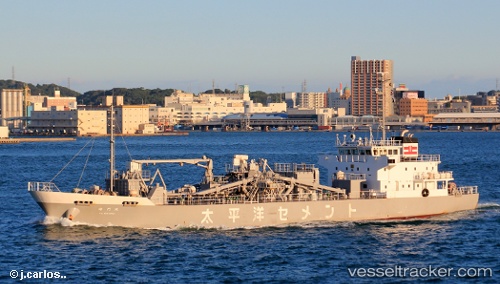
 Kaimonmaru
Current Status
Where is the vessel?
Kaimonmaru is currently in Near Yokkaichi, based on AIS data received less than 1h ago.
Latest AIS update:
Current position: 34.96810° N, 136.67101° E (Near Yokkaichi)
Average speed (last 7 days): Loading…
Average speed (last 30 days): Loading…
Vessel profile: Kaimonmaru is a Cement Carrier with dimensions 76m x 15m.
This page combines live AIS, route history, probable destination signals, nearby traffic, and port activity for practical vessel monitoring.
The current position of vessel Kaimonmaru is 34.96810 lat / 136.67101 lng. Updated: 2026-04-10 03:55:28 UTCNearest reference points:
- Near Yokkaichi
- Near Nagoya
- Near Kinuura
Currently sailing under the flag of Japan ![]()
Details:
Live Vessel Kaimonmaru Analytics (details, animations, etc.)
Recent AIS points (UTC):
2026-04-09 22:19:52 UTC · 34.93191, 136.67239 · SOG 6.3 kn · COG 18°2026-04-09 23:23:41 UTC · 34.95779, 136.64047 · SOG 0 kn · COG 84°
2026-04-10 01:52:42 UTC · 34.95777, 136.64046 · SOG 0 kn · COG 84°
2026-04-10 03:55:28 UTC · 34.96810, 136.67101 · SOG 10.2 kn · COG 103°