 vesseltracker.com
 Newton
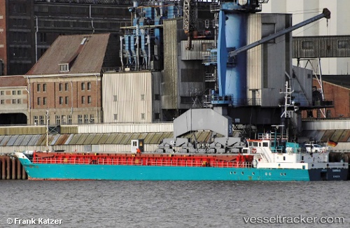
Current Status
Where is the vessel?
Newton is currently in 17 nm SE of Kaavi Paadisadam, based on AIS data received about 12h ago.
Latest AIS update:
Current position: 57.84694° N, 22.65876° E (17 nm SE of Kaavi Paadisadam)
Average speed (last 7 days): Loading…
Average speed (last 30 days): Loading…
Vessel profile: Newton is a Multi Purpose Carrier with dimensions 75m x 10m.
This page combines live AIS, route history, probable destination signals, nearby traffic, and port activity for practical vessel monitoring.
The current position of vessel Newton is 57.84694 lat / 22.65876 lng. Updated: 2026-04-10 07:44:44 UTCNearest reference points:
- 18 nm N of Ventspils
- 11 nm N of Ventspils
- Near Ventspils
Currently sailing under the flag of Antigua Barbuda ![]()
Newton built in 1988 year
Deadweight:
1529 tDetails:
Live Vessel Newton Analytics (details, animations, etc.)
Recent AIS points (UTC):
2026-04-10 02:12:58 UTC · 57.14461, 23.89648 · SOG 10.4 kn · COG 315°2026-04-10 04:03:23 UTC · 57.37958, 23.48871 · SOG 10.4 kn · COG 318°
2026-04-10 05:33:56 UTC · 57.57382, 23.15676 · SOG 10.5 kn · COG 316°
2026-04-10 07:44:44 UTC · 57.84694, 22.65876 · SOG 10.6 kn · COG 300°