 vesseltracker.com
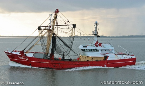
 Uk 2 Adriaantje
Current Status
Where is the vessel?
Uk 2 Adriaantje is currently in Near HARLINGEN, based on AIS data received less than 1h ago.
Latest AIS update:
Current position: 53.17943° N, 5.41467° E (Near HARLINGEN)
Average speed (last 7 days): Loading…
Average speed (last 30 days): Loading…
Vessel profile: Uk 2 Adriaantje is a Fishing Vessel with dimensions 44m x 9m.
This page combines live AIS, route history, probable destination signals, nearby traffic, and port activity for practical vessel monitoring.
The current position of vessel Uk 2 Adriaantje is 53.17943 lat / 5.41467 lng. Updated: 2026-04-05 23:54:53 UTCNearest reference points:
- Near HARLINGEN
- Near FRANEKER
- Near Wonseradeel/Makkum
Currently sailing under the flag of Netherlands ![]()
Uk 2 Adriaantje built in 1990 year
Details:
Live Vessel Uk 2 Adriaantje Analytics (details, animations, etc.)
Recent AIS points (UTC):
2026-04-05 17:39:42 UTC · 53.17944, 5.41467 · SOG 0 kn · COG 346°2026-04-05 19:39:52 UTC · 53.17947, 5.41463 · SOG 0 kn · COG 344°
2026-04-05 21:31:23 UTC · 53.17942, 5.41467 · SOG 0 kn · COG 343°
2026-04-05 23:54:53 UTC · 53.17943, 5.41467 · SOG 0 kn · COG 344°