 vesseltracker.com
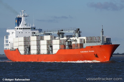
Albemarle Island
Current StatusWhere is the vessel?
Albemarle Island is currently in Near Dover, based on AIS data received less than 1h ago.
Latest AIS update:
Current position: 51.11483° N, 1.31683° E (Near Dover)
Average speed (last 7 days): Loading…
Average speed (last 30 days): Loading…
Vessel profile: Albemarle Island is a Refrigerated Cargo Ship with dimensions 26m x 180m.
This page combines live AIS, route history, probable destination signals, nearby traffic, and port activity for practical vessel monitoring.
The current position of vessel Albemarle Island is 51.11483 lat / 1.31683 lng. Updated: 2026-04-06 12:08:35 UTCNearest reference points:
- Near Dover
- Near Folkestone
- Near RAMSGATE
Details:
Live Vessel Albemarle Island Analytics (details, animations, etc.)
Recent AIS points (UTC):
2026-04-06 05:27:18 UTC · 51.11592, 1.33220 · SOG 2.9 kn · COG 230°2026-04-06 07:56:32 UTC · 51.11485, 1.31682 · SOG 0.1 kn · COG 35°
2026-04-06 10:08:20 UTC · 51.11486, 1.31680 · SOG 0 kn · COG 36°
2026-04-06 12:08:35 UTC · 51.11483, 1.31683 · SOG 0 kn · COG 35°