 vesseltracker.com
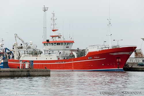
 Rottingoy
Current Status
Where is the vessel?
Rottingoy is currently in Near Lepsøy, based on AIS data received about 1h ago.
Latest AIS update:
Current position: 60.14065° N, 5.37663° E (Near Lepsøy)
Average speed (last 7 days): Loading…
Average speed (last 30 days): Loading…
Vessel profile: Rottingoy is a Fish Carrier with dimensions 60m x 12m.
This page combines live AIS, route history, probable destination signals, nearby traffic, and port activity for practical vessel monitoring.
The current position of vessel Rottingoy is 60.14065 lat / 5.37663 lng. Updated: 2026-03-28 12:32:37 UTCNearest reference points:
- Near SANDVIKVAAG
- Near TORANGSVAG
- Near Damsgård
Currently sailing under the flag of Norway ![]()
Rottingoy built in 1994 year
Deadweight:
130 tDetails:
Live Vessel Rottingoy Analytics (details, animations, etc.)
Recent AIS points (UTC):
2026-03-28 05:20:32 UTC · 60.14057, 5.37669 · SOG 0 kn · COG 220°2026-03-28 07:23:29 UTC · 60.14057, 5.37666 · SOG 0 kn · COG 220°
2026-03-28 09:35:34 UTC · 60.14060, 5.37675 · SOG 0 kn · COG 220°
2026-03-28 12:32:37 UTC · 60.14065, 5.37663 · SOG 0 kn · COG 220°