 vesseltracker.com
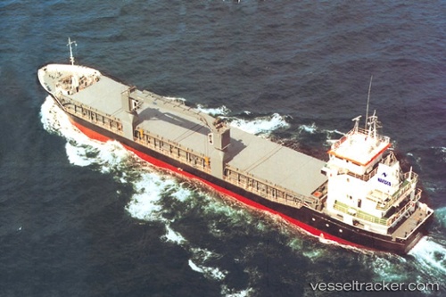
 Pera
Pera
Current Status
Where is the vessel?
Pera is currently in Near Georgetown, based on AIS data received about 1h ago.
Latest AIS update:
Current position: 6.80518° N, 58.16965° W (Near Georgetown)
Average speed (last 7 days): Loading…
Average speed (last 30 days): Loading…
Vessel profile: Pera is a Multi Purpose Carrier with dimensions 87m x 14m.
This page combines live AIS, route history, probable destination signals, nearby traffic, and port activity for practical vessel monitoring.
The current position of vessel Pera is 6.80518 lat / -58.16965 lng. Updated: 2026-04-17 14:54:53 UTCNearest reference points:
- 57 nm NE of Adventure
- 38 nm NW of Jarikaba
Currently sailing under the flag of Antigua Barbuda ![]()
Pera built in 1995 year
Deadweight:
3600 tDetails:
Live Vessel Pera Analytics (details, animations, etc.)
Recent AIS points (UTC):
2026-04-17 06:27:49 UTC · 6.80517, -58.16965 · SOG 0 kn · COG 194°2026-04-17 12:06:53 UTC · 6.80518, -58.16966 · SOG 0 kn · COG 194°
2026-04-17 12:06:53 UTC · 6.80518, -58.16966 · SOG 0 kn · COG 194°
2026-04-17 14:54:53 UTC · 6.80518, -58.16965 · SOG 0 kn · COG 194°