 vesseltracker.com
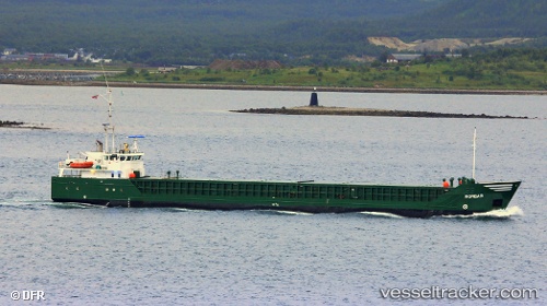
 Norbar
Current Status
Where is the vessel?
Norbar is currently in Near Lutelandet, based on AIS data received less than 1h ago.
Latest AIS update:
Current position: 61.21616° N, 4.78608° E (Near Lutelandet)
Average speed (last 7 days): Loading…
Average speed (last 30 days): Loading…
Vessel profile: Norbar is a General Cargo Ship with dimensions 82m x 11m.
This page combines live AIS, route history, probable destination signals, nearby traffic, and port activity for practical vessel monitoring.
The current position of vessel Norbar is 61.21616 lat / 4.78608 lng. Updated: 2026-04-22 17:46:38 UTCNearest reference points:
- Near Solund
- Near Eivindvik
- Near Eikefjord
Currently sailing under the flag of Norway ![]()
Norbar built in 1995 year
Deadweight:
2500 tDetails:
Live Vessel Norbar Analytics (details, animations, etc.)
Recent AIS points (UTC):
2026-04-22 14:08:57 UTC · 61.76752, 5.02611 · SOG 10.3 kn · COG 225°2026-04-22 16:21:53 UTC · 61.43979, 4.89089 · SOG 10.2 kn · COG 223°
2026-04-22 16:26:57 UTC · 61.42907, 4.87007 · SOG 10.4 kn · COG 223°
2026-04-22 17:46:38 UTC · 61.21616, 4.78608 · SOG 9.9 kn · COG 193°