 vesseltracker.com
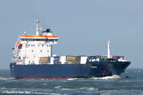
 Arrow
Arrow
Current Status
Where is the vessel?
Arrow is currently in 22 nm SW of Holbury, based on AIS data received less than 1h ago.
Latest AIS update:
Current position: 50.16846° N, 1.60412° W (22 nm SW of Holbury)
Average speed (last 7 days): Loading…
Average speed (last 30 days): Loading…
Vessel profile: Arrow is a Ro Ro Cargo Ship with dimensions 123m x 20m.
This page combines live AIS, route history, probable destination signals, nearby traffic, and port activity for practical vessel monitoring.
The current position of vessel Arrow is 50.16846 lat / -1.60412 lng. Updated: 2026-04-17 11:49:09 UTCNearest reference points:
- 22 nm S of Holbury
- 20 nm S of Holbury
- 11 nm SW of Holbury
Currently sailing under the flag of United Kingdom ![]()
Arrow built in 1998 year
Deadweight:
5656 tDetails:
Live Vessel Arrow Analytics (details, animations, etc.)
Recent AIS points (UTC):
2026-04-17 05:43:13 UTC · 49.17817, -2.11671 · SOG 0 kn · COG 157°2026-04-17 07:24:10 UTC · 49.16069, -2.19889 · SOG 17.1 kn · COG 265°
2026-04-17 09:52:21 UTC · 49.74615, -2.03196 · SOG 16.1 kn · COG 36°
2026-04-17 11:49:09 UTC · 50.16846, -1.60412 · SOG 15.1 kn · COG 21°