 vesseltracker.com
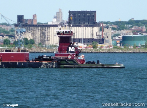
 Barney Turecamo
Current Status
Where is the vessel?
Barney Turecamo is currently in Near Bayway, based on AIS data received less than 1h ago.
Latest AIS update:
Current position: 40.62634° N, 74.20442° W (Near Bayway)
Average speed (last 7 days): Loading…
Average speed (last 30 days): Loading…
Vessel profile: Barney Turecamo is a Pusher Tug with dimensions 156m x 12m.
This page combines live AIS, route history, probable destination signals, nearby traffic, and port activity for practical vessel monitoring.
The current position of vessel Barney Turecamo is 40.62634 lat / -74.20442 lng. Updated: 2026-04-05 14:00:07 UTCNearest reference points:
- Near Bayway
- Near Elizabethport
- Near Port Ivory/Staten Isl/New York
Currently sailing under the flag of USA ![]()
Barney Turecamo built in 1995 year
Deadweight:
401 tDetails:
Live Vessel Barney Turecamo Analytics (details, animations, etc.)
Recent AIS points (UTC):
2026-04-05 07:27:04 UTC · 40.62637, -74.20436 · SOG 0 kn · COG 275°2026-04-05 10:21:04 UTC · 40.62638, -74.20435 · SOG 0 kn · COG 275°
2026-04-05 11:54:00 UTC · 40.62633, -74.20432 · SOG 0 kn · COG 274°
2026-04-05 14:00:07 UTC · 40.62634, -74.20442 · SOG 0 kn · COG 275°