 vesseltracker.com
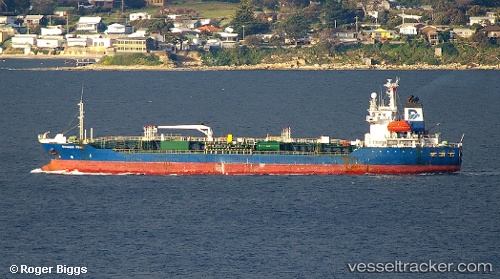
 ANGEL 106
Current Status
Where is the vessel?
ANGEL 106 is currently in Open sea, approx. 465 nm off the nearest listed port, based on AIS data received about 1h ago.
Latest AIS update:
Current position: 6.73833° N, 129.97166° W (Open sea, approx. 465 nm off the nearest listed port)
Average speed (last 7 days): Loading…
Average speed (last 30 days): Loading…
Vessel profile: ANGEL 106 is a Oil/Chemical Tanker with dimensions m x m.
This page combines live AIS, route history, probable destination signals, nearby traffic, and port activity for practical vessel monitoring.
The current position of vessel ANGEL 106 is 6.73833 lat / -129.97166 lng. Updated: 2026-04-19 07:56:05 UTCNearest reference points:
- Open sea, approx. 465 nm off the nearest listed port
- Open sea, approx. 466 nm off the nearest listed port
- Open sea, approx. 469 nm off the nearest listed port
Currently sailing under the flag of Vanuatu ![]()
Details:
Live Vessel ANGEL 106 Analytics (details, animations, etc.)
Recent AIS points (UTC):
2026-04-19 01:53:00 UTC · 6.39133, -129.72160 · SOG 1.2 kn · COG 354°2026-04-19 03:42:00 UTC · 6.39989, -129.73210 · SOG 0.5 kn · COG 359°
2026-04-19 06:04:15 UTC · 6.50769, -129.82169 · SOG 10.5 kn · COG 328°
2026-04-19 07:56:05 UTC · 6.73833, -129.97166 · SOG 0 kn · COG -1°