 vesseltracker.com
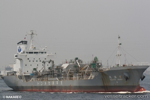
Tenyo Maru
Current StatusWhere is the vessel?
Tenyo Maru is currently in Near SAKAIMINATO, based on AIS data received about 1h ago.
Latest AIS update:
Current position: 35.54418° N, 133.34183° E (Near SAKAIMINATO)
Average speed (last 7 days): Loading…
Average speed (last 30 days): Loading…
Vessel profile: Tenyo Maru is a Cement Carrier with dimensions 17m x 114m.
This page combines live AIS, route history, probable destination signals, nearby traffic, and port activity for practical vessel monitoring.
The current position of vessel Tenyo Maru is 35.54418 lat / 133.34183 lng. Updated: 2026-03-31 16:16:45 UTCNearest reference points:
- Near FUKUYAMA
- 15 nm NW of SHIMONOHAMA
- Near Kurashiki
Details:
Live Vessel Tenyo Maru Analytics (details, animations, etc.)
Recent AIS points (UTC):
2026-03-31 10:13:14 UTC · 35.54460, 133.34364 · SOG 0.3 kn · COG 327°2026-03-31 11:31:04 UTC · 35.54435, 133.34286 · SOG 0 kn · COG 0°
2026-03-31 13:26:47 UTC · 35.54423, 133.34264 · SOG 0.1 kn · COG 358°
2026-03-31 16:16:45 UTC · 35.54418, 133.34183 · SOG 0 kn · COG 35°