 vesseltracker.com
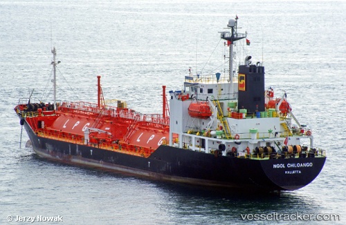
 NGOL CHILOANGO
Current Status
Where is the vessel?
NGOL CHILOANGO is currently in Near Luanda, based on AIS data received about 1h ago.
Latest AIS update:
Current position: 8.73867° S, 13.28833° E (Near Luanda)
Average speed (last 7 days): Loading…
Average speed (last 30 days): Loading…
Vessel profile: NGOL CHILOANGO is a LPG Tanker with dimensions 16m x 96m.
This page combines live AIS, route history, probable destination signals, nearby traffic, and port activity for practical vessel monitoring.
The current position of vessel NGOL CHILOANGO is -8.73867 lat / 13.28833 lng. Updated: 2026-04-18 23:48:43 UTCNearest reference points:
- Near Luanda
- Near Greater Plutonio
Currently sailing under the flag of Belize ![]()
NGOL CHILOANGO built in 1998 year
Deadweight:
3318 tDetails:
Live Vessel NGOL CHILOANGO Analytics (details, animations, etc.)
Recent AIS points (UTC):
2026-04-18 17:28:50 UTC · -8.73900, 13.28933 · SOG 0 kn · COG -1°2026-04-18 19:19:59 UTC · -8.73850, 13.28850 · SOG 0 kn · COG -1°
2026-04-18 21:42:43 UTC · -8.73850, 13.28850 · SOG 0 kn · COG 197°
2026-04-18 23:48:43 UTC · -8.73867, 13.28833 · SOG 0 kn · COG 188°