 vesseltracker.com
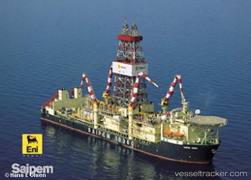
 Saipem 10000
Current Status
Where is the vessel?
Saipem 10000 is currently in 79 nm S of Pinelands, based on AIS data received about 3h ago.
Latest AIS update:
Current position: 32.60582° N, 18.31102° E (79 nm S of Pinelands)
Average speed (last 7 days): Loading…
Average speed (last 30 days): Loading…
Vessel profile: Saipem 10000 is a Drilling Ship with dimensions 228m x 42m.
This page combines live AIS, route history, probable destination signals, nearby traffic, and port activity for practical vessel monitoring.
The current position of vessel Saipem 10000 is 32.60582 lat / 18.31102 lng. Updated: 2026-03-26 07:21:59 UTCNearest reference points:
- 60 nm S of Pinelands
- Near BENGHAZI
- Near Banghazi
Currently sailing under the flag of Bahamas ![]()
Saipem 10000 built in 2000 year
Deadweight:
61118 tDetails:
Live Vessel Saipem 10000 Analytics (details, animations, etc.)
Recent AIS points (UTC):
2026-03-26 01:33:05 UTC · 32.60500, 18.31167 · SOG 0 kn · COG -1°2026-03-26 04:00:03 UTC · 32.60500, 18.31167 · SOG 1 kn · COG -1°
2026-03-26 06:12:10 UTC · 32.60667, 18.31167 · SOG 0 kn · COG -1°
2026-03-26 07:21:59 UTC · 32.60582, 18.31102 · SOG 0.1 kn · COG 325°