 vesseltracker.com
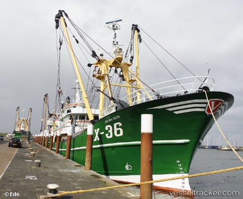
 JAN VAN TOON
Current Status
Where is the vessel?
JAN VAN TOON is currently in Near Ijmuiden, based on AIS data received less than 1h ago.
Latest AIS update:
Current position: 52.45806° N, 4.58479° E (Near Ijmuiden)
Average speed (last 7 days): Loading…
Average speed (last 30 days): Loading…
Vessel profile: JAN VAN TOON is a Fishing Vessel with dimensions m x m.
This page combines live AIS, route history, probable destination signals, nearby traffic, and port activity for practical vessel monitoring.
The current position of vessel JAN VAN TOON is 52.45806 lat / 4.58479 lng. Updated: 2026-04-20 22:03:58 UTCNearest reference points:
- Near Ijmuiden
- Near IJmuiden/Velsen
- Near BEVERWIJK
Currently sailing under the flag of Netherlands ![]()
JAN VAN TOON built in 2000 year
Deadweight:
365 tDetails:
Live Vessel JAN VAN TOON Analytics (details, animations, etc.)
Recent AIS points (UTC):
2026-04-20 19:57:50 UTC · 52.45808, 4.58489 · SOG 0 kn · COG 301°2026-04-20 20:02:59 UTC · 52.45808, 4.58485 · SOG 0 kn · COG 302°
2026-04-20 21:24:59 UTC · 52.45808, 4.58481 · SOG 0 kn · COG 300°
2026-04-20 22:03:58 UTC · 52.45806, 4.58479 · SOG 0 kn · COG 300°