 vesseltracker.com
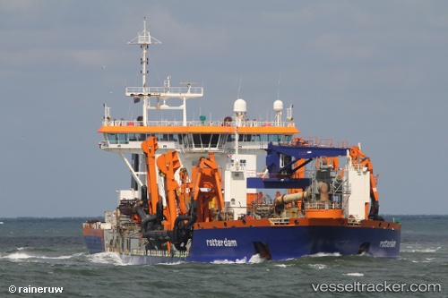
 Rotterdam
Current Status
Where is the vessel?
Rotterdam is currently in Near Karachi, based on AIS data received less than 1h ago.
Latest AIS update:
Current position: 24.82026° N, 66.97263° E (Near Karachi)
Average speed (last 7 days): Loading…
Average speed (last 30 days): Loading…
Vessel profile: Rotterdam is a Hopper Dredger with dimensions 186m x 31m.
This page combines live AIS, route history, probable destination signals, nearby traffic, and port activity for practical vessel monitoring.
The current position of vessel Rotterdam is 24.82026 lat / 66.97263 lng. Updated: 2026-04-19 10:02:55 UTCNearest reference points:
- Near Kiamari
- 16 nm S of Kiamari
- Near PORT QASIM
Currently sailing under the flag of Netherlands ![]()
Rotterdam built in 2001 year
Deadweight:
38000 tDetails:
Live Vessel Rotterdam Analytics (details, animations, etc.)
Recent AIS points (UTC):
2026-04-19 04:09:42 UTC · 24.82022, 66.97259 · SOG 0 kn · COG 8°2026-04-19 06:09:41 UTC · 24.82024, 66.97263 · SOG 0 kn · COG 8°
2026-04-19 07:44:42 UTC · 24.82024, 66.97263 · SOG 0 kn · COG 8°
2026-04-19 10:02:55 UTC · 24.82026, 66.97263 · SOG 0 kn · COG 8°