 vesseltracker.com
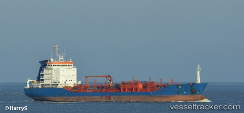
 GSM
GSM
Current Status
Where is the vessel?
GSM is currently in Near Hamriya Free Zone Port, based on AIS data received about 5h ago.
Latest AIS update:
Current position: 25.28394° N, 55.38767° E (Near Hamriya Free Zone Port)
Average speed (last 7 days): Loading…
Average speed (last 30 days): Loading…
Vessel profile: GSM is a Oil/Chemical Tanker with dimensions m x m.
This page combines live AIS, route history, probable destination signals, nearby traffic, and port activity for practical vessel monitoring.
The current position of vessel GSM is 25.28394 lat / 55.38767 lng. Updated: 2026-04-08 10:58:16 UTCNearest reference points:
- Near Mina Rashid Port
- Near Sharjah
- Near Mina Khalid
Currently sailing under the flag of Cook Islands ![]()
Details:
Live Vessel GSM Analytics (details, animations, etc.)
Recent AIS points (UTC):
2026-04-08 03:27:33 UTC · 25.65630, 55.18891 · SOG 48.5 kn · COG 2°2026-04-08 10:58:16 UTC · 25.28394, 55.38767 · SOG 48.5 kn · COG -1°
2026-04-08 10:58:16 UTC · 25.28394, 55.38767 · SOG 48.5 kn · COG -1°
2026-04-08 10:58:16 UTC · 25.28394, 55.38767 · SOG 48.5 kn · COG -1°