 vesseltracker.com
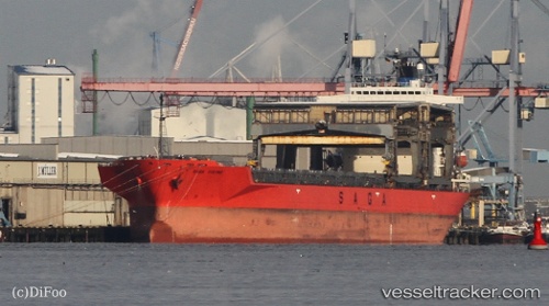
 SAGA VIKING
Current Status
Where is the vessel?
SAGA VIKING is currently in 59 nm E of Kakap Natuna Terminal, based on AIS data received about 20h ago.
Latest AIS update:
Current position: 5.20258° N, 106.91040° E (59 nm E of Kakap Natuna Terminal)
Average speed (last 7 days): Loading…
Average speed (last 30 days): Loading…
Vessel profile: SAGA VIKING is a General Cargo with dimensions m x m.
This page combines live AIS, route history, probable destination signals, nearby traffic, and port activity for practical vessel monitoring.
The current position of vessel SAGA VIKING is 5.20258 lat / 106.91040 lng. Updated: 2026-04-10 07:27:42 UTCNearest reference points:
- 46 nm E of Kakap Natuna Terminal
- 45 nm E of Kakap Natuna Terminal
- 36 nm SW of Slipi
Currently sailing under the flag of Bahamas ![]()
Details:
Live Vessel SAGA VIKING Analytics (details, animations, etc.)
Recent AIS points (UTC):
2026-04-10 01:27:02 UTC · 6.21546, 107.74738 · SOG 12.9 kn · COG 218°2026-04-10 04:05:23 UTC · 5.79332, 107.36321 · SOG 13.2 kn · COG 225°
2026-04-10 05:45:52 UTC · 5.51537, 107.12019 · SOG 13.2 kn · COG 219°
2026-04-10 07:27:42 UTC · 5.20258, 106.91040 · SOG 13.6 kn · COG 210°