 vesseltracker.com
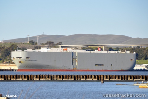
 Mediterraneanhighway
Current Status
Where is the vessel?
Mediterraneanhighway is currently in 98 nm NE of Pinelands, based on AIS data received about 1h ago.
Latest AIS update:
Current position: 35.41000° N, 19.28333° E (98 nm NE of Pinelands)
Average speed (last 7 days): Loading…
Average speed (last 30 days): Loading…
Vessel profile: Mediterraneanhighway is a Vehicles Carrier with dimensions 200m x 32m.
This page combines live AIS, route history, probable destination signals, nearby traffic, and port activity for practical vessel monitoring.
The current position of vessel Mediterraneanhighway is 35.41000 lat / 19.28333 lng. Updated: 2026-03-25 18:13:04 UTCNearest reference points:
- 71 nm N of Pinelands
- 73 nm N of Pinelands
- 103 nm NE of Ryuo
Currently sailing under the flag of Panama ![]()
Mediterraneanhighway built in 2002 year
Deadweight:
17228 tDetails:
Live Vessel Mediterraneanhighway Analytics (details, animations, etc.)
Recent AIS points (UTC):
2026-03-25 12:21:58 UTC · 35.07333, 20.65667 · SOG 11 kn · COG -1°2026-03-25 13:36:59 UTC · 35.14833, 20.37167 · SOG 11 kn · COG -1°
2026-03-25 15:42:57 UTC · 35.25962, 19.87858 · SOG 12.3 kn · COG 293°
2026-03-25 18:13:04 UTC · 35.41000, 19.28333 · SOG 12 kn · COG -1°