 vesseltracker.com
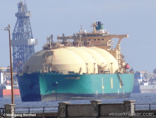
 Lng Akwa Ibom
Current Status
Where is the vessel?
Lng Akwa Ibom is currently in Near Bonny, based on AIS data received less than 1h ago.
Latest AIS update:
Current position: 4.42225° N, 7.14148° E (Near Bonny)
Average speed (last 7 days): Loading…
Average speed (last 30 days): Loading…
Vessel profile: Lng Akwa Ibom is a Lng Tanker with dimensions 288m x 48m.
This page combines live AIS, route history, probable destination signals, nearby traffic, and port activity for practical vessel monitoring.
The current position of vessel Lng Akwa Ibom is 4.42225 lat / 7.14148 lng. Updated: 2026-04-01 17:29:54 UTCNearest reference points:
- Near Bonny
- Near Onne
- Near Ima
Currently sailing under the flag of Bermuda ![]()
Lng Akwa Ibom built in 2004 year
Deadweight:
79633 tDetails:
Live Vessel Lng Akwa Ibom Analytics (details, animations, etc.)
Recent AIS points (UTC):
2026-04-01 11:55:55 UTC · 4.19627, 6.97890 · SOG 7 kn · COG 66°2026-04-01 13:53:01 UTC · 4.42667, 7.13667 · SOG 1 kn · COG -1°
2026-04-01 15:24:00 UTC · 4.42228, 7.14145 · SOG 0 kn · COG 220°
2026-04-01 17:29:54 UTC · 4.42225, 7.14148 · SOG 0 kn · COG 220°