 vesseltracker.com
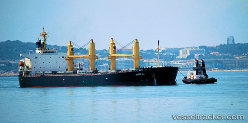
 KANG YU
Current Status
Where is the vessel?
KANG YU is currently in 24 nm NW of Cox's Bazar, based on AIS data received about 1h ago.
Latest AIS update:
Current position: 21.79833° N, 91.80333° E (24 nm NW of Cox's Bazar)
Average speed (last 7 days): Loading…
Average speed (last 30 days): Loading…
Vessel profile: KANG YU is a Bulk Carrier with dimensions 189m x 32m.
This page combines live AIS, route history, probable destination signals, nearby traffic, and port activity for practical vessel monitoring.
The current position of vessel KANG YU is 21.79833 lat / 91.80333 lng. Updated: 2026-04-17 18:04:51 UTCNearest reference points:
- 23 nm NW of Cox's Bazar
- Near Chittagong
- 12 nm NW of Chattogram
Currently sailing under the flag of China Peopless Republic ![]()
KANG YU built in 2004 year
Deadweight:
52988 tDetails:
Live Vessel KANG YU Analytics (details, animations, etc.)
Recent AIS points (UTC):
2026-04-17 11:49:46 UTC · 21.79331, 91.79815 · SOG 0 kn · COG 2°2026-04-17 14:00:57 UTC · 21.79773, 91.79969 · SOG 0.3 kn · COG -1°
2026-04-17 16:04:13 UTC · 21.79833, 91.80333 · SOG 0 kn · COG -1°
2026-04-17 18:04:51 UTC · 21.79833, 91.80333 · SOG 0 kn · COG -1°