 vesseltracker.com
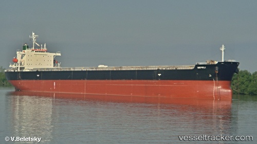
 KHALEJIA ANA 7
Current Status
Where is the vessel?
KHALEJIA ANA 7 is currently in 16 nm SW of Soroosh (Cyrus) Terminal, based on AIS data received about 1d ago.
Latest AIS update:
Current position: 28.86790° N, 49.21967° E (16 nm SW of Soroosh (Cyrus) Terminal)
Average speed (last 7 days): Loading…
Average speed (last 30 days): Loading…
Vessel profile: KHALEJIA ANA 7 is a Bulk Carrier with dimensions m x m.
This page combines live AIS, route history, probable destination signals, nearby traffic, and port activity for practical vessel monitoring.
The current position of vessel KHALEJIA ANA 7 is 28.86790 lat / 49.21967 lng. Updated: 2026-04-19 02:50:42 UTCNearest reference points:
- 19 nm SW of Soroosh (Cyrus) Terminal
- 25 nm W of Soroosh (Cyrus) Terminal
- 31 nm S of Soroosh (Cyrus) Terminal
Currently sailing under the flag of Panama ![]()
Details:
Live Vessel KHALEJIA ANA 7 Analytics (details, animations, etc.)
Recent AIS points (UTC):
2026-04-19 01:12:11 UTC · 28.82985, 49.50475 · SOG 9.1 kn · COG 289°2026-04-19 02:50:42 UTC · 28.86790, 49.21967 · SOG 9.4 kn · COG 273°
2026-04-19 02:50:42 UTC · 28.86790, 49.21967 · SOG 9.4 kn · COG 273°
2026-04-19 02:50:42 UTC · 28.86790, 49.21967 · SOG 9.4 kn · COG 273°