 vesseltracker.com
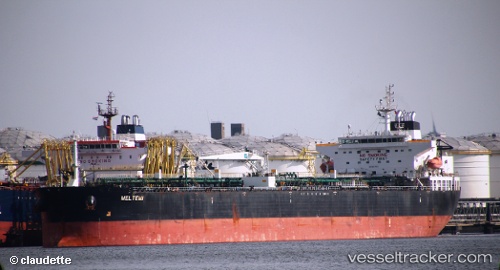
 Meltemi I
Current Status
Where is the vessel?
Meltemi I is currently in 271 nm SW of YORK, based on AIS data received less than 1h ago.
Latest AIS update:
Current position: 4.95855° N, 16.19087° W (271 nm SW of YORK)
Average speed (last 7 days): Loading…
Average speed (last 30 days): Loading…
Vessel profile: Meltemi I is a Crude Oil Tanker with dimensions 50m x 274m.
This page combines live AIS, route history, probable destination signals, nearby traffic, and port activity for practical vessel monitoring.
The current position of vessel Meltemi I is 4.95855 lat / -16.19087 lng. Updated: 2026-04-13 06:01:16 UTCNearest reference points:
- Open sea, approx. 401 nm off the nearest listed port
- Open sea, approx. 405 nm off the nearest listed port
- Open sea, approx. 408 nm off the nearest listed port
Currently sailing under the flag of Liberia ![]()
Meltemi I built in 0 year
Deadweight:
0 tDetails:
Live Vessel Meltemi I Analytics (details, animations, etc.)
Recent AIS points (UTC):
2026-04-12 23:04:15 UTC · 4.89440, -16.26385 · SOG 0.5 kn · COG 81°2026-04-13 02:20:46 UTC · 4.92240, -16.23568 · SOG 0.5 kn · COG 75°
2026-04-13 04:14:05 UTC · 4.94447, -16.21358 · SOG 1.2 kn · COG 80°
2026-04-13 06:01:16 UTC · 4.95855, -16.19087 · SOG 0.7 kn · COG 77°