 vesseltracker.com
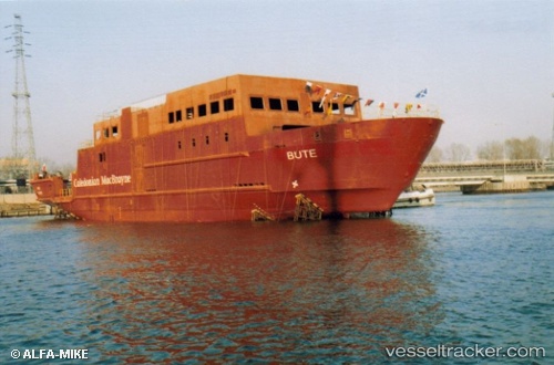
 Bute
Bute
Current Status
Where is the vessel?
Bute is currently in Near Ardyne, based on AIS data received about 2h ago.
Latest AIS update:
Current position: 55.83896° N, 5.05197° W (Near Ardyne)
Average speed (last 7 days): Loading…
Average speed (last 30 days): Loading…
Vessel profile: Bute is a Passenger Ro Ro Cargo Ship with dimensions 72m x 15m.
This page combines live AIS, route history, probable destination signals, nearby traffic, and port activity for practical vessel monitoring.
The current position of vessel Bute is 55.83896 lat / -5.05197 lng. Updated: 2026-03-27 02:16:39 UTCNearest reference points:
- Near Ardyne
- Near Cumbraes
- Near HUNTERS QUAY
Currently sailing under the flag of United Kingdom ![]()
Bute built in 2005 year
Deadweight:
508 tDetails:
Live Vessel Bute Analytics (details, animations, etc.)
Recent AIS points (UTC):
2026-03-26 20:11:39 UTC · 55.83894, -5.05190 · SOG 0 kn · COG 95°2026-03-26 21:58:10 UTC · 55.83896, -5.05194 · SOG 0 kn · COG 95°
2026-03-27 00:01:49 UTC · 55.83896, -5.05194 · SOG 0 kn · COG 95°
2026-03-27 02:16:39 UTC · 55.83896, -5.05197 · SOG 0 kn · COG 95°