 vesseltracker.com
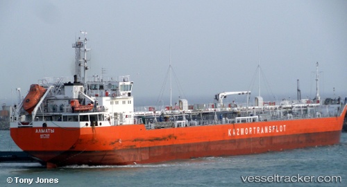
 ALMATY
Current Status
Where is the vessel?
ALMATY is currently in 15 nm W of Aktau, based on AIS data received about 2d ago.
Latest AIS update:
Current position: 43.55383° N, 50.82003° E (15 nm W of Aktau)
Average speed (last 7 days): Loading…
Average speed (last 30 days): Loading…
Vessel profile: ALMATY is a Oil Products Tanker with dimensions 17m x 149m.
This page combines live AIS, route history, probable destination signals, nearby traffic, and port activity for practical vessel monitoring.
The current position of vessel ALMATY is 43.55383 lat / 50.82003 lng. Updated: 2026-03-26 23:51:18 UTCNearest reference points:
- 12 nm S of Aktau
- 24 nm W of Kuryk
- 35 nm W of Kuryk
Currently sailing under the flag of Kazakhstan ![]()
ALMATY built in 2005 year
Deadweight:
12368 tDetails:
Live Vessel ALMATY Analytics (details, animations, etc.)
Recent AIS points (UTC):
2026-03-26 22:25:18 UTC · 43.60641, 51.11927 · SOG 9.3 kn · COG 259°2026-03-26 23:37:27 UTC · 43.56222, 50.86822 · SOG 9.3 kn · COG 257°
2026-03-26 23:51:18 UTC · 43.55383, 50.82003 · SOG 9.3 kn · COG 256°
2026-03-26 23:51:18 UTC · 43.55383, 50.82003 · SOG 9.3 kn · COG 256°