 vesseltracker.com
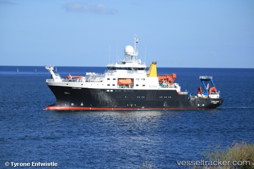
 James Cook
Current Status
Where is the vessel?
James Cook is currently in Near Halifax, based on AIS data received about 1h ago.
Latest AIS update:
Current position: 44.63455° N, 63.56369° W (Near Halifax)
Average speed (last 7 days): Loading…
Average speed (last 30 days): Loading…
Vessel profile: James Cook is a Research Vessel with dimensions 89m x 18m.
This page combines live AIS, route history, probable destination signals, nearby traffic, and port activity for practical vessel monitoring.
The current position of vessel James Cook is 44.63455 lat / -63.56369 lng. Updated: 2026-04-20 11:39:19 UTCNearest reference points:
- Near Halifax
- Near Eastern Passage
- 20 nm S of Head of Jeddore
Currently sailing under the flag of United Kingdom ![]()
James Cook built in 2006 year
Deadweight:
2463 tDetails:
Live Vessel James Cook Analytics (details, animations, etc.)
Recent AIS points (UTC):
2026-04-20 07:50:52 UTC · 44.63455, -63.56368 · SOG 0 kn · COG 250°2026-04-20 10:10:17 UTC · 44.63455, -63.56369 · SOG 0 kn · COG 250°
2026-04-20 10:24:30 UTC · 44.63455, -63.56369 · SOG 0 kn · COG 251°
2026-04-20 11:39:19 UTC · 44.63455, -63.56369 · SOG 0 kn · COG 251°