 vesseltracker.com
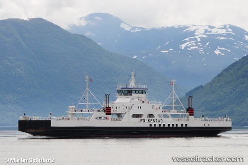
 Folkestad
Current Status
Where is the vessel?
Folkestad is currently in Near Jøvik, based on AIS data received about 1h ago.
Latest AIS update:
Current position: 69.66303° N, 19.80819° E (Near Jøvik)
Average speed (last 7 days): Loading…
Average speed (last 30 days): Loading…
Vessel profile: Folkestad is a Passenger Ro Ro Cargo Ship with dimensions 87m x 16m.
This page combines live AIS, route history, probable destination signals, nearby traffic, and port activity for practical vessel monitoring.
The current position of vessel Folkestad is 69.66303 lat / 19.80819 lng. Updated: 2026-04-17 03:42:19 UTCNearest reference points:
- Near Tromsø
- Near Tromso
- Near Sørkjosen
Currently sailing under the flag of Norway ![]()
Folkestad built in 2006 year
Deadweight:
655 tDetails:
Live Vessel Folkestad Analytics (details, animations, etc.)
Recent AIS points (UTC):
2026-04-16 21:56:06 UTC · 69.66302, 19.80816 · SOG 0 kn · COG 225°2026-04-16 23:22:38 UTC · 69.66302, 19.80823 · SOG 0 kn · COG 225°
2026-04-17 02:38:58 UTC · 69.66302, 19.80822 · SOG 0 kn · COG 225°
2026-04-17 03:42:19 UTC · 69.66303, 19.80819 · SOG 0 kn · COG 225°