 vesseltracker.com
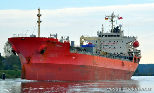
 EASTERLY AS OMARIA
Current Status
Where is the vessel?
EASTERLY AS OMARIA is currently in Near Fort Gratiot, based on AIS data received less than 1h ago.
Latest AIS update:
Current position: 43.09823° N, 82.35405° W (Near Fort Gratiot)
Average speed (last 7 days): Loading…
Average speed (last 30 days): Loading…
Vessel profile: EASTERLY AS OMARIA is a Chemical/Oil Products Tanker with dimensions 146m x 24m.
This page combines live AIS, route history, probable destination signals, nearby traffic, and port activity for practical vessel monitoring.
The current position of vessel EASTERLY AS OMARIA is 43.09823 lat / -82.35405 lng. Updated: 2026-04-13 17:28:00 UTCNearest reference points:
- Near Fort Gratiot
- Near Saint Clair Shores
- Near Walkerville
Currently sailing under the flag of Marshall Islands ![]()
EASTERLY AS OMARIA built in 2007 year
Deadweight:
19974 tDetails:
Live Vessel EASTERLY AS OMARIA Analytics (details, animations, etc.)
Recent AIS points (UTC):
2026-04-13 11:43:00 UTC · 43.09918, -82.35478 · SOG 0.2 kn · COG 217°2026-04-13 14:12:59 UTC · 43.09863, -82.35419 · SOG 0.1 kn · COG 252°
2026-04-13 15:59:11 UTC · 43.09833, -82.35333 · SOG 0 kn · COG -1°
2026-04-13 17:28:00 UTC · 43.09823, -82.35405 · SOG 0.1 kn · COG 260°