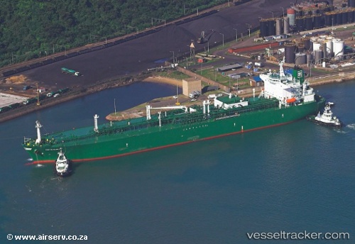
.
Vessel photo of GAS ALYSSA (IMO 9364394) vesseltracker.com

ID flag GAS ALYSSA

Vessel type: LPG Tanker | IMO: 9364394 | MMSI: MMSI: 525401047
Call sign: YDQU2 | Dimensions: 36 m x 226 m
Current Status

Where is the vessel?

GAS ALYSSA is currently in Open sea (no nearby ports in database), based on AIS data received about 1h ago.

Latest AIS update:

Current position: 2.55460° S, 84.17434° E (Open sea (no nearby ports in database))

Average speed (last 7 days): Loading…

Average speed (last 30 days): Loading…

Vessel profile: GAS ALYSSA is a LPG Tanker with dimensions 36m x 226m.

This page combines live AIS, route history, probable destination signals, nearby traffic, and port activity for practical vessel monitoring.

The current position of vessel GAS ALYSSA is -2.55460 lat / 84.17434 lng. Updated: 2026-04-12 13:44:50 UTC
Nearest reference points:
  • Open sea (no nearby ports in database)

Currently sailing under the flag of Indonesia ID flag

GAS ALYSSA built in 2008 year

Deadweight:
54789 t

Details:

Live Vessel GAS ALYSSA Analytics (details, animations, etc.)


Recent AIS points (UTC):
2026-04-12 07:15:31 UTC · -3.58890, 82.88518 · SOG 15.5 kn · COG 55°
2026-04-12 09:38:04 UTC · -3.22581, 83.37105 · SOG 14.8 kn · COG 54°
2026-04-12 11:23:35 UTC · -2.93671, 83.71005 · SOG 15.4 kn · COG 50°
2026-04-12 13:44:50 UTC · -2.55460, 84.17434 · SOG 15.6 kn · COG 54°

Track of the vessel in the last 60 days


UTC: --
Start: -- Track timeline (UTC) End: --
Encountered: --


Link to the map:


Find another ship

GAS_ALYSSA (525401047) last ports (portcalls and passsages)

Sungai Udang Port | 2025-09-08 20:07:19
BUKOM ISLAND | 2025-09-05 07:33:50
JURONG ISLAND | 2025-09-01 08:08:26
JURONG ISLAND | 2025-08-28 07:23:16
JURONG ISLAND | 2025-08-24 06:05:58
JURONG ISLAND | 2025-08-20 05:31:01
BUKOM ISLAND | 2025-08-17 23:16:30
PULAU SAMBU | 2025-08-17 21:31:31
BATU AMPAR | 2025-08-17 21:03:55
PENGERANG | 2025-08-17 19:48:05
SURALAYA | 2025-08-08 11:24:21
BAKAUHENI | 2025-08-08 10:15:01
BUKOM ISLAND | 2025-05-10 21:55:49
PULAU SAMBU | 2025-05-10 21:10:53
TANAH MERAH | 2025-05-10 19:49:08
SURALAYA | 2025-05-03 18:20:07
SIR BANIYAS | 2025-04-20 06:32:42
Sebang | 2025-04-10 22:01:11
BUKOM ISLAND | 2025-04-06 09:54:36
PULAU SAMBU | 2025-04-06 08:25:24
PENGERANG | 2025-04-06 07:13:41
BAKAUHENI | 2025-03-26 18:42:03
Az Zarqa Island | 2025-03-12 22:43:34
CIWANDAN | 2025-02-26 18:13:23
SURALAYA | 2025-02-26 09:13:57
JURONG ISLAND | 2025-02-23 20:54:59
BUKOM ISLAND | 2025-02-23 19:22:34
PULAU SAMBU | 2025-02-23 18:49:23
TANAH MERAH | 2025-02-23 17:21:00
BAKAUHENI | 2025-02-21 18:51:14
Sebang | 2024-11-28 08:34:56
JURONG ISLAND | 2024-11-25 21:55:30
BUKOM ISLAND | 2024-11-25 20:01:44
TANAH MERAH | 2024-11-25 18:17:29
Az Zarqa Island | 2024-10-30 22:17:42
Sebang | 2024-10-21 17:06:59
Selat Lombok | 2024-10-10 17:52:54
Singapore | 2024-07-10 20:19:02
Selat Sunda | 2024-07-06 11:25:07
Panjang | 2024-07-06 08:34:55
Singapore | 2024-03-09 16:27:01
Az Zarqa Island | 2024-02-12 12:00:26
Singapore | 2024-02-01 23:43:56
Sambu | 2024-02-01 23:04:56
Sebang | 2023-10-03 08:04:33
Singapore | 2023-09-30 22:31:44
Sambu | 2023-09-30 21:42:29
Singapore | 2023-07-09 04:34:19
Tandjung Uban | 2023-07-08 00:30:11
Tandjung Uban | 2023-07-03 23:42:34
Sambu | 2023-06-03 00:43:57
Tandjung Uban | 2023-02-26 20:23:27
Tandjung Uban | 2023-02-22 17:05:20
Tandjung Uban | 2023-02-18 14:34:15
Mina Az Zawr | 2023-02-05 08:55:20
Mina Abd Allah | 2023-02-05 05:02:06
Tandjung Uban | 2023-01-21 05:29:43
Sambu | 2022-02-22 21:30:52
Wusong | 2022-02-11 06:03:33
Sambu | 2022-01-19 08:45:39
Singapore | 2022-01-19 08:35:38
Sirri Island | 2022-01-06 03:40:20
Singapore | 2021-12-27 01:25:07
Sambu | 2021-12-27 01:15:55
Nansha | 2021-12-20 05:06:40
Umm Said | 2021-12-01 12:10:00