 vesseltracker.com
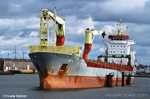
 Onego Bayou
Current Status
Where is the vessel?
Onego Bayou is currently in Near Yxpila, based on AIS data received about 1h ago.
Latest AIS update:
Current position: 63.86053° N, 23.03494° E (Near Yxpila)
Average speed (last 7 days): Loading…
Average speed (last 30 days): Loading…
Vessel profile: Onego Bayou is a Multi Purpose Carrier with dimensions 145m x 145m.
This page combines live AIS, route history, probable destination signals, nearby traffic, and port activity for practical vessel monitoring.
The current position of vessel Onego Bayou is 63.86053 lat / 23.03494 lng. Updated: 2026-04-05 13:27:41 UTCNearest reference points:
- Near Karlsborg Axelvik
Currently sailing under the flag of Antigua Barbuda ![]()
Onego Bayou built in 2007 year
Deadweight:
10758 tDetails:
Live Vessel Onego Bayou Analytics (details, animations, etc.)
Recent AIS points (UTC):
2026-04-05 08:09:41 UTC · 63.86051, 23.03496 · SOG 0 kn · COG 292°2026-04-05 10:15:40 UTC · 63.86049, 23.03496 · SOG 0 kn · COG 292°
2026-04-05 12:00:41 UTC · 63.86048, 23.03490 · SOG 0 kn · COG 292°
2026-04-05 13:27:41 UTC · 63.86053, 23.03494 · SOG 0 kn · COG 291°