 vesseltracker.com
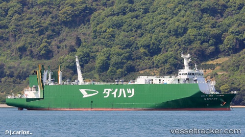
Daihatsu Maru 2
Current StatusWhere is the vessel?
Daihatsu Maru 2 is currently in 10 nm W of TADOTSU, based on AIS data received about 1h ago.
Latest AIS update:
Current position: 34.27575° N, 133.53693° E (10 nm W of TADOTSU)
Average speed (last 7 days): Loading…
Average speed (last 30 days): Loading…
Vessel profile: Daihatsu Maru 2 is a Vehicles Carrier with dimensions 16m x 105m.
This page combines live AIS, route history, probable destination signals, nearby traffic, and port activity for practical vessel monitoring.
The current position of vessel Daihatsu Maru 2 is 34.27575 lat / 133.53693 lng. Updated: 2026-03-30 16:00:39 UTCNearest reference points:
- Near FUKUYAMA
- Near MIZUSHIMA
- Near Kurashiki
Details:
Live Vessel Daihatsu Maru 2 Analytics (details, animations, etc.)
Recent AIS points (UTC):
2026-03-30 09:52:48 UTC · 34.35527, 132.47548 · SOG 0 kn · COG 242°2026-03-30 11:35:40 UTC · 34.07051, 132.46529 · SOG 15.6 kn · COG 131°
2026-03-30 13:50:55 UTC · 34.11021, 132.98917 · SOG 10.9 kn · COG 142°
2026-03-30 16:00:39 UTC · 34.27575, 133.53693 · SOG 14.8 kn · COG 75°