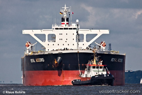
.
Vessel photo of Royal Accord (IMO 9393187) vesseltracker.com

Royal Accord

Vessel type: Bulk Carrier | IMO: 9393187 | MMSI: MMSI: 370064000
Call sign: 3EUA9 | Dimensions: 45 m x 290 m
Current Status

Where is the vessel?

Royal Accord is currently in 382 nm S of Al Azaiba, based on AIS data received about 1h ago.

Latest AIS update:

Current position: 29.70517° S, 56.53090° E (382 nm S of Al Azaiba)

Average speed (last 7 days): Loading…

Average speed (last 30 days): Loading…

Vessel profile: Royal Accord is a Bulk Carrier with dimensions 45m x 290m.

This page combines live AIS, route history, probable destination signals, nearby traffic, and port activity for practical vessel monitoring.

The current position of vessel Royal Accord is -29.70517 lat / 56.53090 lng. Updated: 2026-03-29 04:12:19 UTC
Nearest reference points:
  • Open sea, approx. 403 nm off the nearest listed port
  • Open sea, approx. 402 nm off the nearest listed port
  • Open sea, approx. 404 nm off the nearest listed port
Details:

Live Vessel Royal Accord Analytics (details, animations, etc.)


Recent AIS points (UTC):
2026-03-28 22:13:08 UTC · -29.97823, 55.53898 · SOG 10.8 kn · COG 76°
2026-03-28 23:43:49 UTC · -29.90475, 55.84229 · SOG 11 kn · COG 69°
2026-03-29 00:57:44 UTC · -29.83294, 56.08705 · SOG 11 kn · COG 70°
2026-03-29 04:12:19 UTC · -29.70517, 56.53090 · SOG 10.9 kn · COG 71°

Track of the vessel in the last 28 days


UTC: --
Start: -- Track timeline (UTC) End: --
Encountered: --


Link to the map:


Find another ship

Royal_Accord (370064000) last ports (portcalls and passsages)

GANGAVARAM | 2025-07-11 07:30:50
GANGAVARAM | 2025-07-07 07:21:10
BATU AMPAR | 2025-04-13 04:48:35
TANAH MERAH | 2025-04-11 03:26:32
TANAH MERAH | 2025-04-07 02:21:16
PENGERANG | 2025-04-07 01:55:29
Yen-Tai | 2025-03-27 03:35:39
Fangcheng | 2025-03-18 03:45:03
PENGERANG | 2025-02-18 14:56:55
BATU AMPAR | 2025-02-18 13:22:17
PULAU SAMBU | 2025-02-18 12:42:24
Sebang | 2025-02-16 09:20:53
Cape Of Good Hope | 2025-01-28 13:14:00
Sebang | 2024-12-10 06:33:24
PULAU SAMBU | 2024-12-08 07:02:50
TANAH MERAH | 2024-12-07 11:23:39
PENGERANG | 2024-12-07 10:22:00
Yen-Tai | 2024-11-27 18:22:19
Yen-Tai | 2024-11-23 17:54:21
CAOFEIDIAN | 2024-11-17 17:52:07
Fangcheng | 2024-08-12 13:47:32
Fangcheng | 2024-08-08 13:27:06
Cape Of Good Hope | 2024-07-11 08:49:58
Singapore | 2024-05-08 08:22:36
Yen-Tai | 2024-04-28 16:35:29
Yen-Tai | 2024-04-24 13:38:55
Nagoya | 2024-03-28 19:59:18
Nagoya | 2024-03-24 19:58:57
Oita | 2024-03-19 12:35:15
Sambu | 2024-03-07 07:23:15
Sept Iles | 2024-01-14 23:58:56
Sept Iles | 2024-01-10 23:27:05
Sept Iles | 2024-01-06 23:03:22
Sept Iles | 2024-01-02 22:04:27
Sept Iles | 2023-12-29 20:59:12
Bishop Rock | 2023-12-18 06:05:38
Singapore | 2023-10-03 19:26:42
Zamboanga | 2023-09-28 06:16:24
Gladstone Harbor | 2023-09-14 17:37:20
Jingjiang | 2023-08-18 09:32:00
Wusong | 2023-08-18 05:37:23
Zhangjiagang | 2023-08-17 06:58:12
Nantong | 2023-08-15 03:59:29
Taicang | 2023-08-15 00:55:12
Wusong | 2023-08-14 02:28:04
Jingjiang | 2023-08-13 21:22:57
Selat Lombok | 2023-07-24 08:55:45
Port Headland | 2023-07-19 07:51:00
Selat Lombok | 2023-07-15 13:27:39
Selat Lombok | 2023-06-01 13:34:05
Samson Point | 2023-05-27 15:32:46
Selat Lombok | 2023-05-22 04:38:39
Singapore | 2023-04-28 03:10:56
Ra’S Shukhayr | 2023-04-10 05:22:16
Bur Ibrahim | 2023-04-09 18:30:51
Gijon | 2023-03-23 20:22:08
Bishop Rock | 2023-02-26 08:31:37
Puerto De La Luz | 2023-01-31 05:47:18
Cape Of Good Hope | 2022-12-23 23:49:42
Singapore | 2022-12-03 15:12:45
Morro Redondo | 2022-09-20 19:26:40
Morro Redondo | 2022-09-16 16:57:13
Samson Point | 2022-07-24 04:25:46
Samson Point | 2022-06-18 07:30:31
Kao-Hsiung Kang | 2022-05-31 22:40:22
Xiamen | 2022-05-31 04:37:36
Xiamen | 2022-05-27 04:14:17
Selat Lombok | 2022-05-07 07:12:18
Samson Point | 2022-05-02 12:19:31
Wusong | 2022-04-18 07:04:37
Selat Lombok | 2022-03-21 14:55:48
Dampier | 2022-03-16 06:20:10
Selat Lombok | 2022-03-08 21:47:12
Selat Sunda | 2022-02-08 09:34:02
Sao Luiz | 2021-12-02 21:53:33
Port Headland | 2021-09-30 16:06:40