 vesseltracker.com
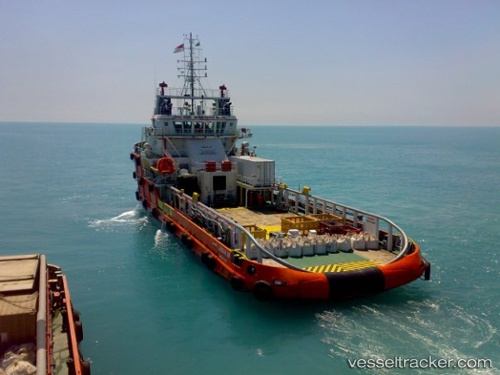
 HIRAB
HIRAB
Current Status
Where is the vessel?
HIRAB is currently in 66 nm W of Dai Hung (Tandem Load), based on AIS data received about 7d ago.
Latest AIS update:
Current position: 8.22096° N, 107.60207° E (66 nm W of Dai Hung (Tandem Load))
Average speed (last 7 days): Loading…
Average speed (last 30 days): Loading…
Vessel profile: HIRAB is a Offshore Tug/Supply Ship with dimensions 15m x 59m.
This page combines live AIS, route history, probable destination signals, nearby traffic, and port activity for practical vessel monitoring.
The current position of vessel HIRAB is 8.22096 lat / 107.60207 lng. Updated: 2026-04-10 08:06:40 UTCNearest reference points:
- 30 nm SW of Dai Hung (Tandem Load)
- 59 nm SW of Bach Ho
- 11 nm N of Gombong
Currently sailing under the flag of Tanzania ![]()
HIRAB built in 2007 year
Deadweight:
1364 tDetails:
Live Vessel HIRAB Analytics (details, animations, etc.)
Recent AIS points (UTC):
2026-04-10 01:34:23 UTC · 9.00215, 107.40252 · SOG 7.5 kn · COG 161°2026-04-10 04:13:44 UTC · 8.68272, 107.48839 · SOG 7.4 kn · COG 176°
2026-04-10 05:44:54 UTC · 8.49967, 107.53185 · SOG 7.4 kn · COG 172°
2026-04-10 08:06:40 UTC · 8.22096, 107.60207 · SOG 6.9 kn · COG 176°