.
Vessel photo of Ladycharm (IMO 9421843) vesseltracker.com

Ladycharm

Vessel type: Bulk Carrier | IMO: 9421843 | MMSI: MMSI: 209171000
Call sign: V7PX5 | Dimensions: 45 m x 290 m
Current Status

Where is the vessel?

Ladycharm is currently in 335 nm W of Calang, based on AIS data received about 1h ago.

Latest AIS update:

Current position: 2.62412° N, 90.36581° E (335 nm W of Calang)

Average speed (last 7 days): Loading…

Average speed (last 30 days): Loading…

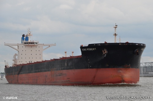
Vessel profile: Ladycharm is a Bulk Carrier with dimensions 45m x 290m.

This page combines live AIS, route history, probable destination signals, nearby traffic, and port activity for practical vessel monitoring.

The current position of vessel Ladycharm is 2.62412 lat / 90.36581 lng. Updated: 2026-04-19 16:44:42 UTC
Nearest reference points:
  • Open sea, approx. 407 nm off the nearest listed port
  • Open sea, approx. 414 nm off the nearest listed port
  • Open sea, approx. 406 nm off the nearest listed port
Details:

Live Vessel Ladycharm Analytics (details, animations, etc.)


Recent AIS points (UTC):
2026-04-19 13:35:59 UTC · 2.99482, 90.86672 · SOG 12.1 kn · COG 231°
2026-04-19 15:50:54 UTC · 2.72765, 90.51245 · SOG 12 kn · COG 232°
2026-04-19 16:44:42 UTC · 2.62412, 90.36581 · SOG 11.7 kn · COG 232°

Track of the vessel in the last 60 days


UTC: --
Start: -- Track timeline (UTC) End: --
Encountered: --


Link to the map:


Find another ship

Ladycharm (209171000) last ports (portcalls and passsages)

PULAU SAMBU | 2025-07-03 06:56:13
TANAH MERAH | 2025-07-02 05:44:51
Panjang | 2025-06-08 07:41:03
JURONG ISLAND | 2025-03-13 22:14:16
PULAU SAMBU | 2025-03-13 20:42:53
TANAH MERAH | 2025-03-12 22:34:35
PENGERANG | 2025-03-12 21:18:16
JINGTANG | 2025-02-07 06:43:18
PENGERANG | 2025-01-24 07:38:33
TANAH MERAH | 2025-01-23 12:25:06
BATU AMPAR | 2025-01-23 10:47:15
BUKOM ISLAND | 2025-01-23 09:21:30
Singapore | 2024-11-01 01:59:47
Singapore | 2024-09-28 20:17:49
Sao Luiz | 2024-08-18 08:37:26
Ponta da Madeira | 2024-08-18 07:22:02
Singapore | 2024-07-12 03:04:57
Jingjiang | 2024-07-03 18:50:29
Zhangjiagang | 2024-07-01 07:00:21
Nantong | 2024-07-01 04:22:37
Taicang | 2024-07-01 01:17:12
Wusong | 2024-06-30 10:55:55
Singapore | 2024-06-11 17:27:36
Sambu | 2024-04-04 10:39:56
Singapore | 2024-04-03 23:11:47
Jingjiang | 2024-03-27 16:30:35
Wusong | 2024-03-27 11:05:43
Taicang | 2024-03-25 19:28:09
Lianyungang | 2024-03-19 19:25:48
Singapore | 2024-03-08 05:16:29
Richards Bay | 2024-02-19 01:07:23
Richards Bay | 2024-02-13 17:55:17
Richards Bay | 2024-02-09 17:24:27
Richards Bay | 2024-02-05 16:43:28
Maputo | 2024-02-01 17:20:23
Vishakhapatnam | 2024-01-12 16:53:21
Vishakhapatnam | 2024-01-08 16:45:50
Vishakhapatnam | 2024-01-04 16:44:07
Torres Strait | 2023-07-08 09:55:31
Gladstone Harbor | 2023-05-30 15:38:39
Gladstone Harbor | 2023-04-24 20:36:22
Davao | 2023-04-12 21:53:24
Selat Lombok | 2023-01-10 23:43:26
Dampier | 2023-01-06 23:10:20
Selat Lombok | 2023-01-03 17:48:04
Dampier | 2022-12-06 08:23:43
Selat Lombok | 2022-11-05 20:44:54
Dampier | 2022-11-01 11:06:29
Samson Point | 2022-09-26 04:26:51
Samson Point | 2022-09-22 01:42:22
Samson Point | 2022-09-17 22:36:07
Nagasaki | 2022-09-02 16:37:13
Selat Lombok | 2022-08-16 07:29:50
Dampier | 2022-08-12 01:23:44
Selat Lombok | 2022-08-03 07:28:57
Wusong | 2022-07-22 10:54:49
Selat Lombok | 2022-07-10 01:21:55
Dampier | 2022-07-05 19:11:09
Port Headland | 2022-05-10 16:35:47
Singapore | 2022-01-19 19:35:52
Manila | 2022-01-13 22:14:32
Wusong | 2022-01-02 04:18:03
Port Hedland | 2021-12-05 03:18:24
Port Headland | 2021-12-03 19:50:24