 vesseltracker.com
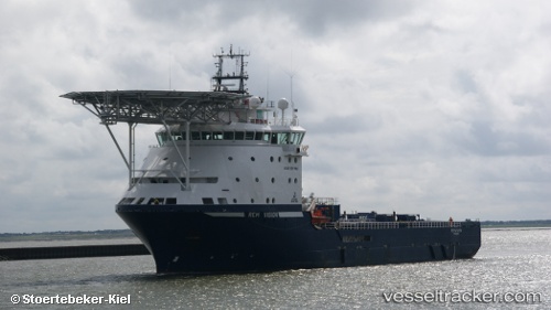
 Normand Tonjer
Current Status
Where is the vessel?
Normand Tonjer is currently in 195 nm NW of Port Mathurin, based on AIS data received less than 1h ago.
Latest AIS update:
Current position: 17.63583° S, 60.74650° E (195 nm NW of Port Mathurin)
Average speed (last 7 days): Loading…
Average speed (last 30 days): Loading…
Vessel profile: Normand Tonjer is a Offshore Tug Supply Ship with dimensions 96m x 23m.
This page combines live AIS, route history, probable destination signals, nearby traffic, and port activity for practical vessel monitoring.
The current position of vessel Normand Tonjer is -17.63583 lat / 60.74650 lng. Updated: 2026-04-02 11:58:49 UTCNearest reference points:
- 219 nm NW of Port Mathurin
- 106 nm NW of Port Mathurin
- 159 nm W of Rodrigues
Currently sailing under the flag of Norway ![]()
Normand Tonjer built in 2010 year
Deadweight:
5260 tDetails:
Live Vessel Normand Tonjer Analytics (details, animations, etc.)
Recent AIS points (UTC):
2026-04-02 06:09:02 UTC · -18.19547, 59.89387 · SOG 11 kn · COG 55°2026-04-02 08:05:14 UTC · -18.00583, 60.16450 · SOG 10.1 kn · COG 57°
2026-04-02 10:15:55 UTC · -17.79562, 60.48623 · SOG 10.9 kn · COG 57°
2026-04-02 11:58:49 UTC · -17.63583, 60.74650 · SOG 11 kn · COG 55°