 vesseltracker.com
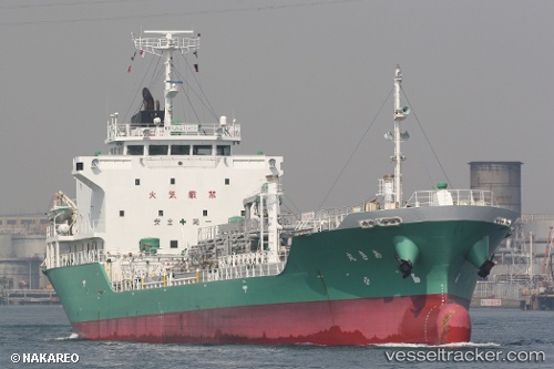
 Aki Maru
Current Status
Where is the vessel?
Aki Maru is currently in Near Kamisu, Ibaraki, based on AIS data received less than 1h ago.
Latest AIS update:
Current position: 35.91000° N, 140.67500° E (Near Kamisu, Ibaraki)
Average speed (last 7 days): Loading…
Average speed (last 30 days): Loading…
Vessel profile: Aki Maru is a Oil Products Tanker with dimensions 105m x 16m.
This page combines live AIS, route history, probable destination signals, nearby traffic, and port activity for practical vessel monitoring.
The current position of vessel Aki Maru is 35.91000 lat / 140.67500 lng. Updated: 2026-03-30 09:19:36 UTCNearest reference points:
- Near KASHIMA
- Near Mito
- 12 nm E of CHOSHI
Currently sailing under the flag of Japan ![]()
Aki Maru built in 2008 year
Deadweight:
4999 tDetails:
Live Vessel Aki Maru Analytics (details, animations, etc.)
Recent AIS points (UTC):
2026-03-30 03:10:32 UTC · 35.90833, 140.67667 · SOG 0 kn · COG -1°2026-03-30 05:04:31 UTC · 35.90833, 140.67667 · SOG 0 kn · COG -1°
2026-03-30 07:58:31 UTC · 35.90833, 140.67667 · SOG 0 kn · COG -1°
2026-03-30 09:19:36 UTC · 35.91000, 140.67500 · SOG 1 kn · COG -1°