 vesseltracker.com
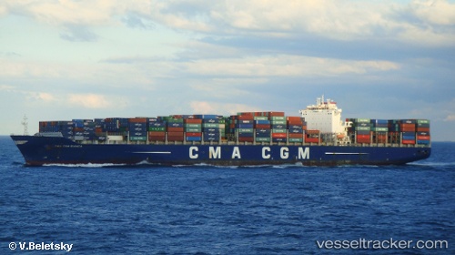
 Cma Cgm Bianca
Current Status
Where is the vessel?
Cma Cgm Bianca is currently in 14 nm SE of Ketu, based on AIS data received about 1h ago.
Latest AIS update:
Current position: 6.42578° N, 4.00693° E (14 nm SE of Ketu)
Average speed (last 7 days): Loading…
Average speed (last 30 days): Loading…
Vessel profile: Cma Cgm Bianca is a Container Ship with dimensions 335m x 43m.
This page combines live AIS, route history, probable destination signals, nearby traffic, and port activity for practical vessel monitoring.
The current position of vessel Cma Cgm Bianca is 6.42578 lat / 4.00693 lng. Updated: 2026-04-04 23:33:32 UTCNearest reference points:
- Near Lagos
- Near Apapa
- Near Kirikiri
Currently sailing under the flag of Malta ![]()
Cma Cgm Bianca built in 2011 year
Deadweight:
101433 tDetails:
Live Vessel Cma Cgm Bianca Analytics (details, animations, etc.)
Recent AIS points (UTC):
2026-04-04 17:36:32 UTC · 6.42582, 4.00693 · SOG 0 kn · COG 280°2026-04-04 20:00:32 UTC · 6.42580, 4.00702 · SOG 0.1 kn · COG 280°
2026-04-04 22:15:32 UTC · 6.42578, 4.00697 · SOG 0.1 kn · COG 280°
2026-04-04 23:33:32 UTC · 6.42578, 4.00693 · SOG 0 kn · COG 280°