 vesseltracker.com
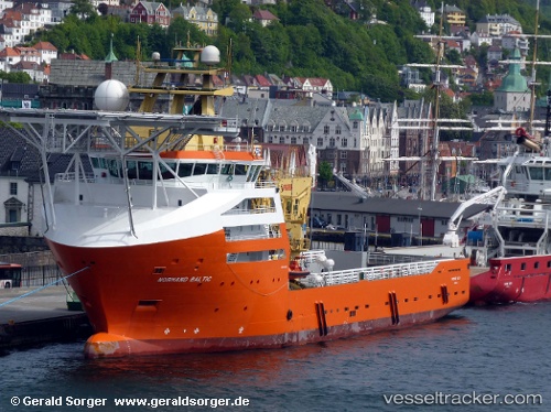
 Normand Baltic
Current Status
Where is the vessel?
Normand Baltic is currently in 31 nm NW of MAILIAO, based on AIS data received about 1h ago.
Latest AIS update:
Current position: 24.21145° N, 119.85076° E (31 nm NW of MAILIAO)
Average speed (last 7 days): Loading…
Average speed (last 30 days): Loading…
Vessel profile: Normand Baltic is a Offshore Support Vessel with dimensions 96m x 20m.
This page combines live AIS, route history, probable destination signals, nearby traffic, and port activity for practical vessel monitoring.
The current position of vessel Normand Baltic is 24.21145 lat / 119.85076 lng. Updated: 2026-04-22 01:58:06 UTCNearest reference points:
- Near MAILIAO
- 13 nm N of MAGONG
- Near Tai-tung Kang
Currently sailing under the flag of United Kingdom ![]()
Normand Baltic built in 2010 year
Deadweight:
4100 tDetails:
Live Vessel Normand Baltic Analytics (details, animations, etc.)
Recent AIS points (UTC):
2026-04-21 21:59:50 UTC · 24.21092, 119.85201 · SOG 0.1 kn · COG 209°2026-04-22 00:06:56 UTC · 24.20333, 119.83833 · SOG 0 kn · COG -1°
2026-04-22 01:31:39 UTC · 24.20781, 119.84228 · SOG 0.5 kn · COG 209°
2026-04-22 01:58:06 UTC · 24.21145, 119.85076 · SOG 1.3 kn · COG -1°