 vesseltracker.com
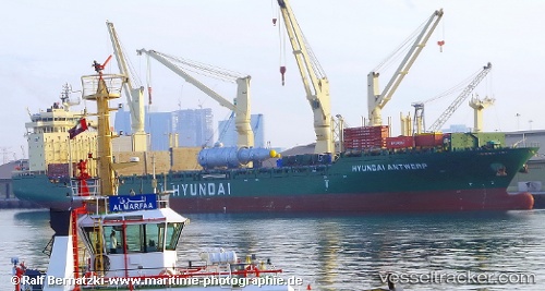
Hyundai Antwerp
Current StatusWhere is the vessel?
Hyundai Antwerp is currently in Open sea, approx. 533 nm off the nearest listed port, based on AIS data received less than 1h ago.
Latest AIS update:
Current position: 34.25129° N, 160.91022° W (Open sea, approx. 533 nm off the nearest listed port)
Average speed (last 7 days): Loading…
Average speed (last 30 days): Loading…
Vessel profile: Hyundai Antwerp is a Multi Purpose Carrier with dimensions 28m x 193m.
This page combines live AIS, route history, probable destination signals, nearby traffic, and port activity for practical vessel monitoring.
The current position of vessel Hyundai Antwerp is 34.25129 lat / -160.91022 lng. Updated: 2026-04-16 21:39:06 UTCNearest reference points:
- Open sea, approx. 533 nm off the nearest listed port
- Open sea, approx. 544 nm off the nearest listed port
- Open sea, approx. 546 nm off the nearest listed port
Details:
Live Vessel Hyundai Antwerp Analytics (details, animations, etc.)
Recent AIS points (UTC):
2026-04-16 13:44:43 UTC · 34.80754, -163.00410 · SOG 13.8 kn · COG 108°2026-04-16 16:25:43 UTC · 34.61667, -162.29832 · SOG 13 kn · COG -1°
2026-04-16 20:10:38 UTC · 34.36206, -161.30115 · SOG 13.8 kn · COG 110°
2026-04-16 21:39:06 UTC · 34.25129, -160.91022 · SOG 13.9 kn · COG 107°