 vesseltracker.com
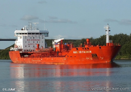
 Harbour Fashion
Current Status
Where is the vessel?
Harbour Fashion is currently in 35 nm E of Fox River (=riviere-Au-Renard), based on AIS data received less than 1h ago.
Latest AIS update:
Current position: 49.01595° N, 63.49298° W (35 nm E of Fox River (=riviere-Au-Renard))
Average speed (last 7 days): Loading…
Average speed (last 30 days): Loading…
Vessel profile: Harbour Fashion is a Chemical Oil Products Tanker with dimensions 143m x 22m.
This page combines live AIS, route history, probable destination signals, nearby traffic, and port activity for practical vessel monitoring.
The current position of vessel Harbour Fashion is 49.01595 lat / -63.49298 lng. Updated: 2026-04-05 13:45:24 UTCCurrently sailing under the flag of Portugal ![]()
Harbour Fashion built in 2011 year
Deadweight:
16878 tDetails:
Live Vessel Harbour Fashion Analytics (details, animations, etc.)
Recent AIS points (UTC):
2026-04-05 08:24:33 UTC · 49.35153, -65.11015 · SOG 12.6 kn · COG 97°2026-04-05 09:25:14 UTC · 49.33337, -64.78326 · SOG 12.8 kn · COG 100°
2026-04-05 11:49:15 UTC · 49.21464, -64.04251 · SOG 12.7 kn · COG 118°
2026-04-05 13:45:24 UTC · 49.01595, -63.49298 · SOG 12.9 kn · COG 124°