 vesseltracker.com
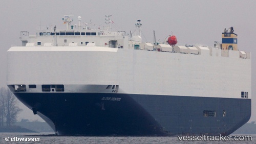
 Glovis Countess
Current Status
Where is the vessel?
Glovis Countess is currently in 59 nm S of Dokdo, based on AIS data received less than 1h ago.
Latest AIS update:
Current position: 36.26833° N, 131.59167° E (59 nm S of Dokdo)
Average speed (last 7 days): Loading…
Average speed (last 30 days): Loading…
Vessel profile: Glovis Countess is a Vehicles Carrier with dimensions 200m x 32m.
This page combines live AIS, route history, probable destination signals, nearby traffic, and port activity for practical vessel monitoring.
The current position of vessel Glovis Countess is 36.26833 lat / 131.59167 lng. Updated: 2026-04-06 01:17:29 UTCNearest reference points:
- 67 nm W of NAKANOSHIMA
- 63 nm NW of Unnan
- 37 nm NW of NAKANOSHIMA
Currently sailing under the flag of Marshall Islands ![]()
Glovis Countess built in 2010 year
Deadweight:
18701 tDetails:
Live Vessel Glovis Countess Analytics (details, animations, etc.)
Recent AIS points (UTC):
2026-04-05 15:29:34 UTC · 38.04500, 134.48334 · SOG 18 kn · COG -1°2026-04-05 22:17:02 UTC · 36.80749, 132.43324 · SOG 17 kn · COG 231°
2026-04-05 23:38:31 UTC · 36.57667, 132.04167 · SOG 17 kn · COG -1°
2026-04-06 01:17:29 UTC · 36.26833, 131.59167 · SOG 17 kn · COG -1°