 vesseltracker.com
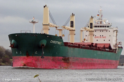
 Chestnut
Current Status
Where is the vessel?
Chestnut is currently in Near Proctor, based on AIS data received less than 1h ago.
Latest AIS update:
Current position: 46.76934° N, 92.10610° W (Near Proctor)
Average speed (last 7 days): Loading…
Average speed (last 30 days): Loading…
Vessel profile: Chestnut is a Bulk Carrier with dimensions 185m x 24m.
This page combines live AIS, route history, probable destination signals, nearby traffic, and port activity for practical vessel monitoring.
The current position of vessel Chestnut is 46.76934 lat / -92.10610 lng. Updated: 2026-04-20 19:49:24 UTCNearest reference points:
- Near La Pointe
Currently sailing under the flag of Liberia ![]()
Chestnut built in 2010 year
Deadweight:
30809 tDetails:
Live Vessel Chestnut Analytics (details, animations, etc.)
Recent AIS points (UTC):
2026-04-20 16:07:25 UTC · 46.76932, -92.10612 · SOG 0 kn · COG 242°2026-04-20 17:28:28 UTC · 46.76932, -92.10612 · SOG 0 kn · COG 242°
2026-04-20 19:37:43 UTC · 46.76833, -92.10500 · SOG 0 kn · COG -1°
2026-04-20 19:49:24 UTC · 46.76934, -92.10610 · SOG 0 kn · COG 242°